
Energy
Pipeline
Our team of veteran pipeline specialists excel at acquiring right-of-way for pipeline projects. Over 40 years, we’ve leased over 10,000 miles of right-of-way and worked for all of the major pipeline operators. Whether it’s transmission or distribution, FERC-regulated or intrastate, our time-tested process and relentless focus on getting results makes Doyle a sought-after vendor for every type of pipeline project.
We provide our services for all types of pipeline products, including natural gas, oil, hydrogen, ammonia, liquified natural gas, CO2, and water. If it flows through a pipe, we can help you acquire the easements for it.

Pipeline Services
Project Management
Our project management is what sets us apart. We know how to drive a tight schedule, communicate with landowners, and keep you well-informed on every detail of our activities. We require regular, detailed and clear reporting from our team members so you can report to your leadership and we can make the difficult decisions when the project is at a crossroads.
Public Outreach
Public Outreach cultivates understanding, trust, and collaboration between your project and the surrounding communities. Our team works with you and all relevant partners to develop and implement custom outreach strategies that foster positive relationships, address concerns, and ensure transparent communication with stakeholders throughout your project’s lifecycle.
Route and Site Identification and Evaluation
Route and Site Identification and Evaluation are vital to planning and developing a successful project. Using the advanced tools of the Doyle Data and Mapping System, industry expertise, and in-depth research, our team navigates the complexities of site selection to recommend the most optimal pathways or locations for infrastructure projects. We use strategic insights and data-driven guidance to optimize your project’s success — whether it’s a pipeline, transmission line, or renewable energy installation.
Abstracting and Title Examination
Our team of efficient and experienced title agents provide thorough, reliable research on property ownership, title status, and potential encumbrances. We combine extensive industry knowledge with years of specialized expertise to support your title research needs, including, preparation of Limited Title Reports, Title Curative, and Title Document Management.
Easement, Lease and Fee Acquisition
Throughout the Easement, Lease, and Fee Acquisition phase, we work diligently to secure the land rights and agreements for your infrastructure projects. Our decades of negotiation experience has led to the development of successful acquisition strategies and processes that can be customized to meet your project’s unique objectives and timeline.
Expert Witness Representation
We collaborate with our clients to provide credible and persuasive testimony in legal proceedings related to land acquisition, property rights, and infrastructure projects. Our team will provide authoritative and reliable expertise, supported by years of in-depth industry experience and a thorough understanding of relevant laws, regulations, and best practices.

Acquisition Status
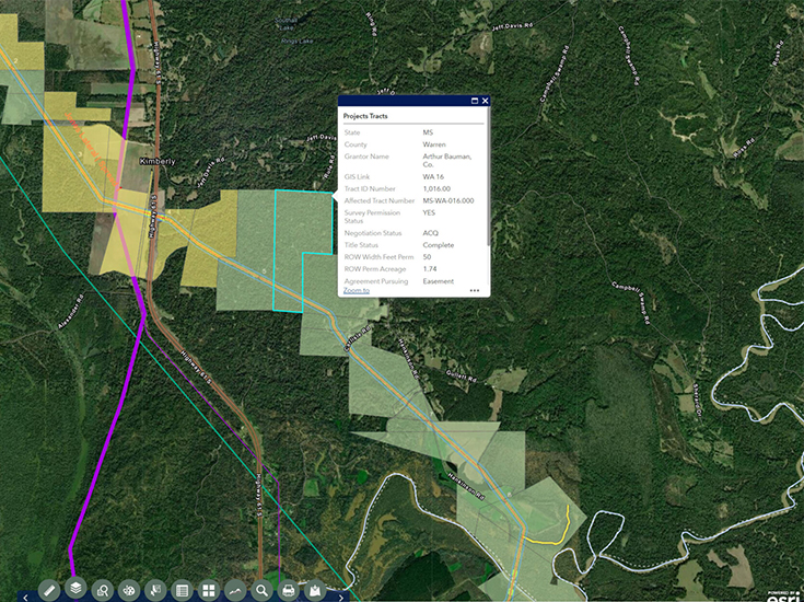
Tract Information
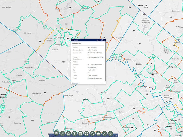
Public Outreach
Sample Maps
FOR PIPELINE
Our Geographic Information System (GIS) technology significantly streamlines the pipeline right-of-way process.
Acquisition Status
This layer allows us to easily visualize where we are having success and where we need to make more progress in the negotiation and acquisition process.
Exhibit Map
Within this system, we can quickly produce high-quality exhibit drawings to share with landowners as a reference for easement location.
Tract Information
We use this system to visualize target areas and quickly identify high-priority parcels based on proximity to a substation, transmission line, or other point of interconnection.
Public Outreach
In this view, we can visualize any relevant information about key political stakeholders with whom we need to engage for project approval.

Doyle Data and GIS Mapping System
Doyle utilizes cutting-edge Geographic Information System (GIS) technology, allowing us to manage every detail of your right-of-way project. This application not only centralizes data management, but also allows clients and field staff to remotely access reporting, mapping, and file-sharing tools.